氣候變化威脅著自然生態(tài)系統(tǒng)與社會(huì)經(jīng)濟(jì)系統(tǒng),而二氧化碳被認(rèn)為是氣候變化的主要驅(qū)動(dòng)因素�����?�?茖W(xué)的現(xiàn)狀評(píng)估是實(shí)現(xiàn)生態(tài)修復(fù)碳增匯目標(biāo)的實(shí)踐基礎(chǔ)�����。
導(dǎo)讀
面對(duì)全球氣候變化�,亟需將“雙碳”目標(biāo)納入國(guó)土空間規(guī)劃實(shí)踐。目前�,以碳增匯為導(dǎo)向,針對(duì)中國(guó)西部地區(qū)�、特別是西北干旱區(qū)縣域的生態(tài)修復(fù)研究較少。本研究以中國(guó)新疆維吾爾自治區(qū)溫宿縣為例��,從碳吸收能力與碳儲(chǔ)量?jī)煞矫婢C合評(píng)估溫宿縣碳匯現(xiàn)狀�����,并以此為基礎(chǔ)識(shí)別溫宿縣碳匯空間格局��,探索以碳增匯為導(dǎo)向的縣域國(guó)土空間生態(tài)修復(fù)規(guī)劃的途徑。現(xiàn)狀評(píng)估結(jié)果表明����,溫宿縣的碳匯重要性在不同地理區(qū)域呈現(xiàn)出較大差異。在研究區(qū)域內(nèi)識(shí)別出一處碳匯腹地����、兩處碳匯重要區(qū)��,以及總面積達(dá)2259.81km2的碳匯潛力帶�����,進(jìn)而結(jié)合土地利用現(xiàn)狀提煉出8種土地利用典型空間模型��,并擬定了相應(yīng)的生態(tài)修復(fù)策略�����。研究有助于促進(jìn)“雙碳”目標(biāo)在國(guó)土空間規(guī)劃中的落實(shí)����,對(duì)中國(guó)西北干旱區(qū)域碳匯管理實(shí)踐具有積極意義,并可為地理?xiàng)l件相似的地區(qū)提供固碳增匯的經(jīng)驗(yàn)�����。
關(guān)鍵詞
碳增匯;碳吸收�����;碳儲(chǔ)量��;縣域�����;西北干旱區(qū)���;生態(tài)修復(fù)����;國(guó)土空間規(guī)劃
以碳增匯為導(dǎo)向的縣域
國(guó)土空間生態(tài)修復(fù)研究
——以中國(guó)新疆維吾爾自治區(qū)溫宿縣為例
Research on the Territorial Ecological Restoration of Counties for the Increase of Carbon Sinks
—A Case Study of Wensu County, Xinjiang Uygur Autonomous Region, China
01引言
氣候變化威脅著自然生態(tài)系統(tǒng)與社會(huì)經(jīng)濟(jì)系統(tǒng)�,而二氧化碳被認(rèn)為是氣候變化的主要驅(qū)動(dòng)因素?����?茖W(xué)的現(xiàn)狀評(píng)估是實(shí)現(xiàn)生態(tài)修復(fù)碳增匯目標(biāo)的實(shí)踐基礎(chǔ)�����。然而,現(xiàn)有研究對(duì)中國(guó)西部地區(qū)��、特別是西北干旱區(qū)的縣域研究較少���。在生態(tài)修復(fù)方面�,現(xiàn)有研究較少結(jié)合生態(tài)空間格局提出生態(tài)修復(fù)策略��。
本研究以中國(guó)新疆維吾爾自治區(qū)溫宿縣作為研究場(chǎng)地�����。為了在碳增匯導(dǎo)向下探究中國(guó)西北干旱地區(qū)縣域的國(guó)土空間生態(tài)修復(fù)途徑�,從而促進(jìn)“雙碳”目標(biāo)在國(guó)土空間規(guī)劃中的落實(shí)�,并為地理?xiàng)l件相似的地區(qū)提供可參考的范式,研究旨在探討以下問(wèn)題:
2)有哪些基于碳增匯的國(guó)土空間生態(tài)修復(fù)途徑�����?
3)本研究可以為中國(guó)西北干旱區(qū)及相似地區(qū)的碳匯管理提供哪些參考��?
02研究區(qū)域與數(shù)據(jù)概況
研究區(qū)域
溫宿縣隸屬中國(guó)新疆維吾爾自治區(qū)阿克蘇地區(qū),位于天山中段的托木爾峰南麓���、塔里木盆地北緣地形總體呈“北高南低”的特征�����。溫宿縣屬溫帶大陸性干旱氣候�,干旱少雨���、蒸發(fā)量大�、光照充足�����,土地利用類型主要為未利用土地����、草地與耕地,土壤類型主要為鈣積石膏土�����、石化石膏土�����、粘化鈣積土等,植被類型主要為荒漠和草甸�,其縣域具有廣闊的自然空間,碳匯潛力巨大�����。
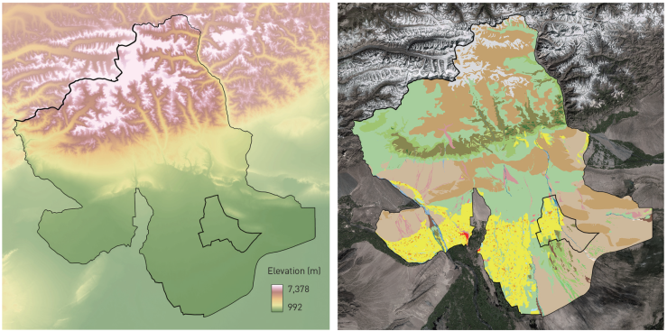

研究區(qū)域高程與土地利用現(xiàn)狀 ? 張?chǎng)ノ?�,楊穎�����,袁藝�,韓靜怡����,李迪華
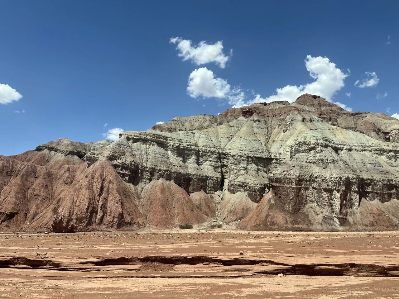
溫宿縣戈壁風(fēng)景 ? 韓靜怡
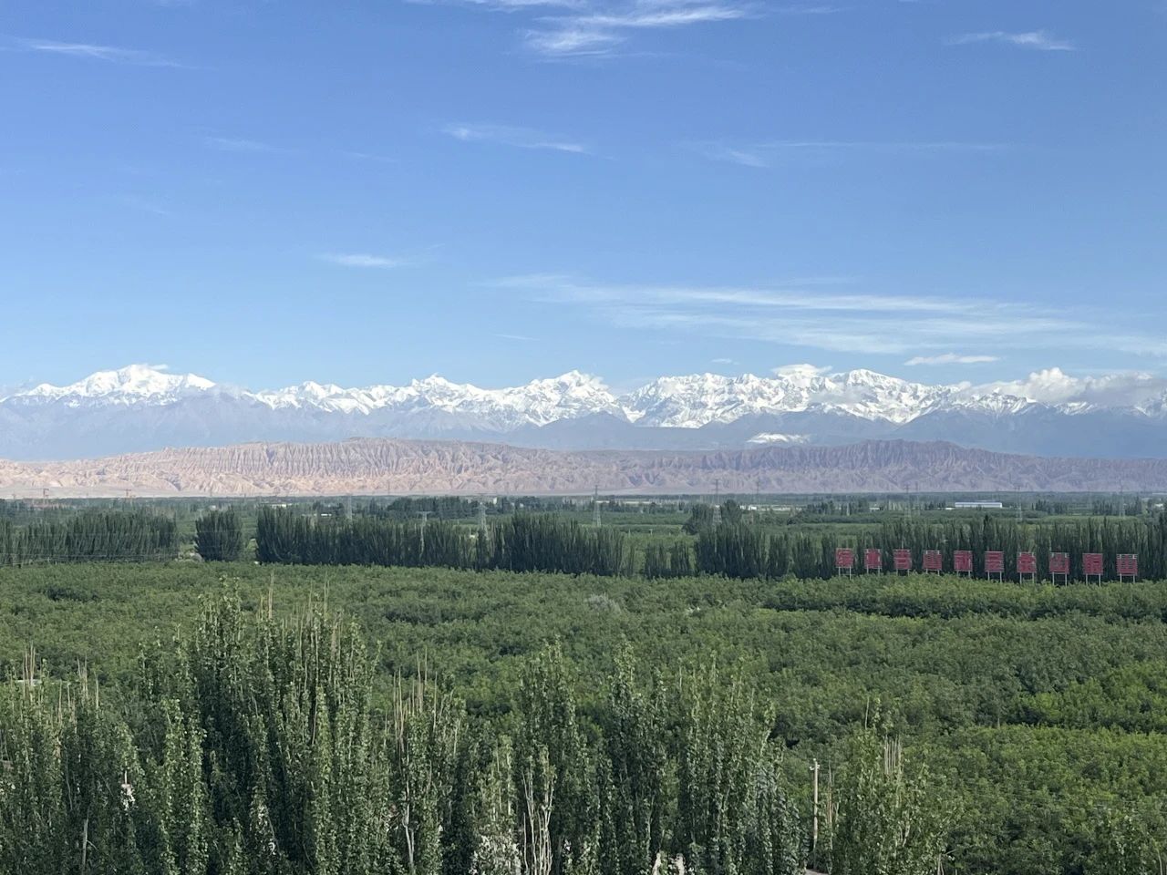
溫宿縣林草風(fēng)光 ? 韓靜怡
數(shù)據(jù)來(lái)源與預(yù)處理
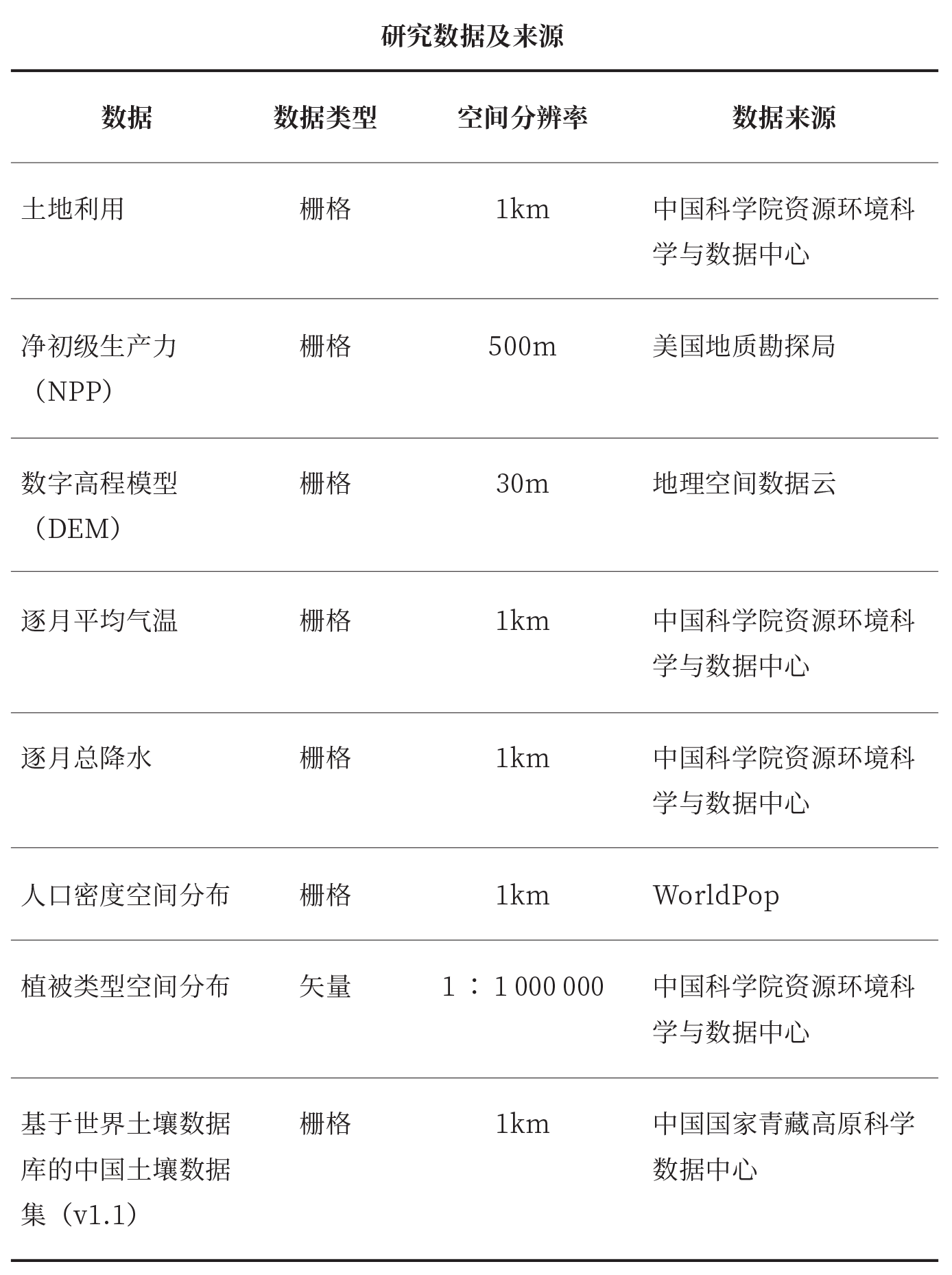
在對(duì)數(shù)據(jù)的更新時(shí)間、可獲取性�����、時(shí)空同步情況����,以及不同年份的數(shù)據(jù)質(zhì)量進(jìn)行綜合考慮后��,選用2015年多源數(shù)據(jù)展開(kāi)研究���。將所用數(shù)據(jù)在ArcGIS10.3中統(tǒng)一投影為1980西安坐標(biāo)系,并轉(zhuǎn)化為1km精度的柵格���。
研究框架
研究按照“碳匯現(xiàn)狀評(píng)價(jià)-空間格局識(shí)別-修復(fù)策略擬定”的框架展開(kāi):首先���,對(duì)溫宿縣碳匯的現(xiàn)狀(碳吸收、碳儲(chǔ)量)和重要性進(jìn)行評(píng)估���;其次�����,識(shí)別溫宿縣碳匯空間格局����;最終在前期分析的指導(dǎo)下���,通過(guò)總結(jié)現(xiàn)有研究中的固碳增匯管理措施��,針對(duì)溫宿縣土地利用現(xiàn)狀擬定生態(tài)修復(fù)策略����。
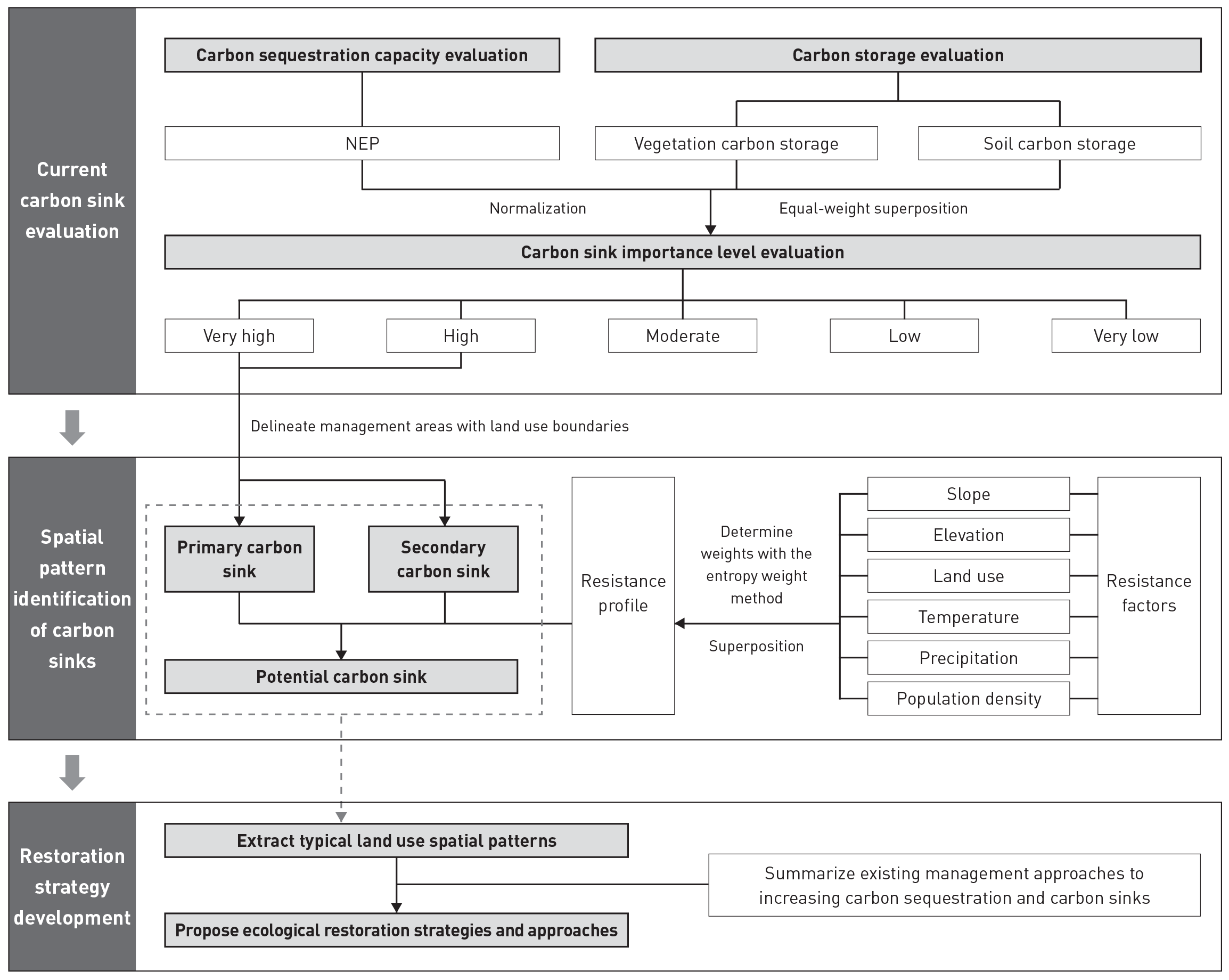
研究框架 ? 張?chǎng)ノ模瑮罘f�����,袁藝���,韓靜怡����,李迪華
碳匯現(xiàn)狀評(píng)價(jià)
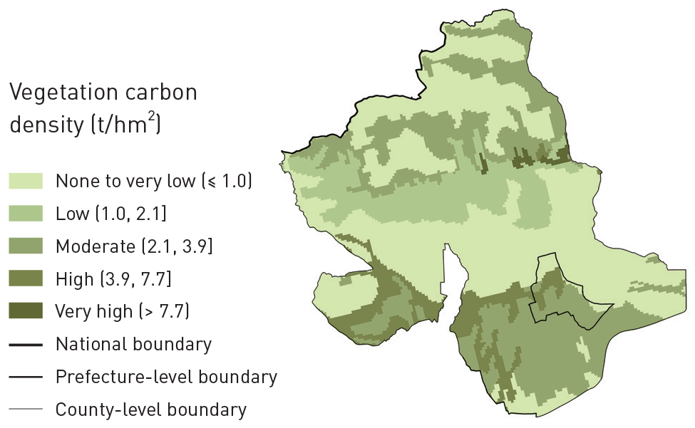
溫宿縣碳吸收能力通過(guò)NEP進(jìn)行度量����,取值為凈初級(jí)生產(chǎn)力(NPP)與土壤微生物呼吸碳排放(RH)的差值�。因溫宿縣土壤碳酸鹽含量較高,因而在進(jìn)行碳儲(chǔ)量評(píng)價(jià)時(shí)應(yīng)對(duì)土壤與植被進(jìn)行綜合考量���。土壤碳儲(chǔ)量由表土無(wú)機(jī)碳含量���、表土有機(jī)碳含量���、底土無(wú)機(jī)碳含量、底土有機(jī)碳含量構(gòu)成���。研究結(jié)合現(xiàn)有研究與場(chǎng)地地理位置��、海拔高度����、氣候特征等場(chǎng)地情況確定植被碳密度��,并計(jì)算溫宿縣植被碳儲(chǔ)量�����。
植被碳儲(chǔ)量空間分布 ? 張?chǎng)ノ?���,楊穎,袁藝�����,韓靜怡��,李迪華
研究采用等權(quán)重方式對(duì)二者的指標(biāo)進(jìn)行疊加。首先��,分別對(duì)NEP����、植被碳密度、土壤碳密度計(jì)算進(jìn)行極差標(biāo)準(zhǔn)化����,然后進(jìn)行疊加,得到碳匯重要性的評(píng)價(jià)結(jié)果��,并采用自然斷點(diǎn)法分為“極高”����、“高”、“中”���、“低”和“極低”5個(gè)等級(jí)����。
碳匯空間格局
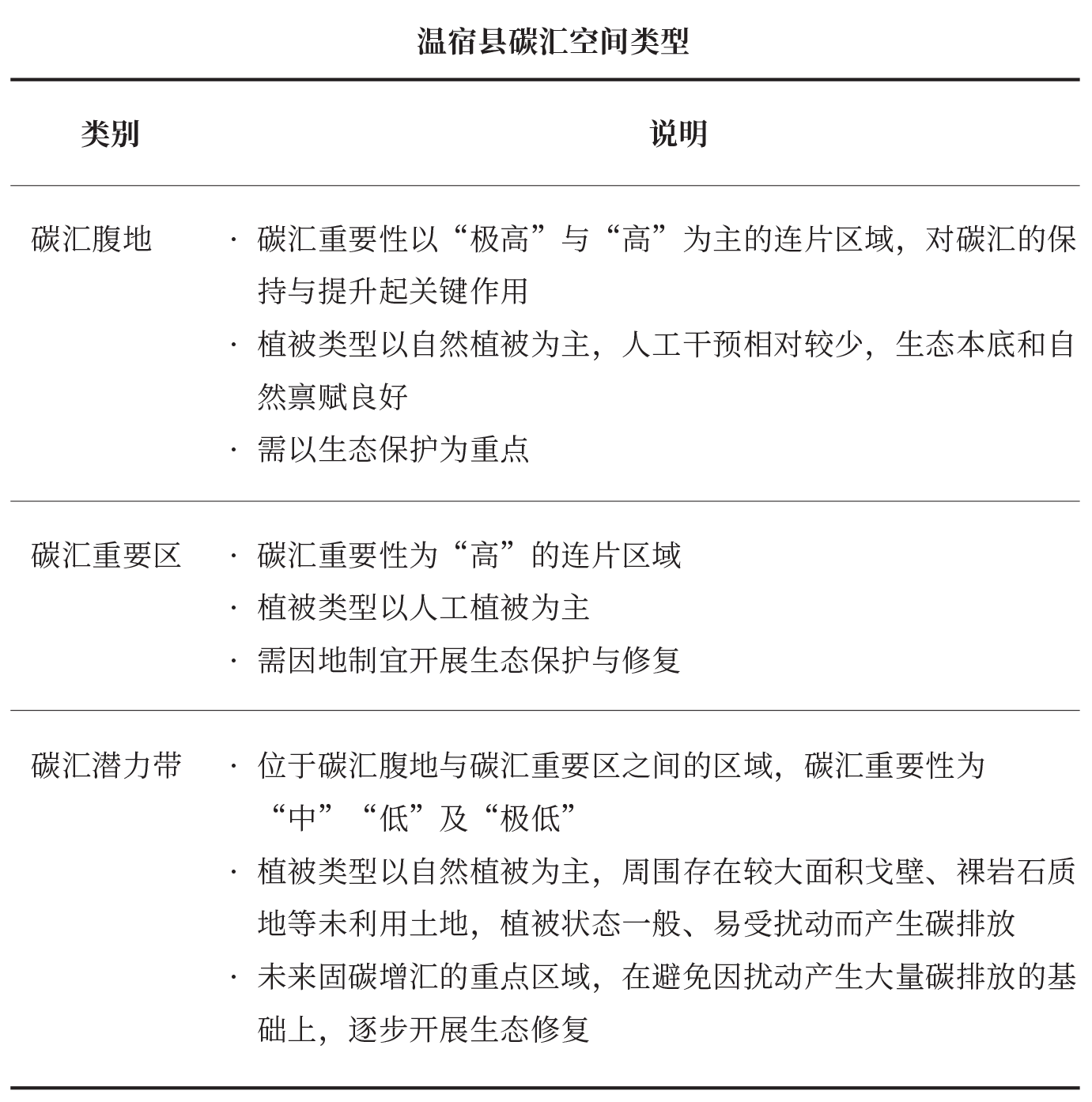
參考景觀生態(tài)學(xué)中的空間格局相關(guān)概念����,本研究將溫宿縣碳匯空間識(shí)別為碳匯腹地、碳匯重要區(qū)與碳匯潛力帶三大空間類型�。
在碳匯重要性評(píng)價(jià)的基礎(chǔ)上,提取評(píng)級(jí)為“極高”與“高”的區(qū)域��,以土地利用的邊界作為管控的邊界��,識(shí)別碳匯腹地與重要區(qū)�����。
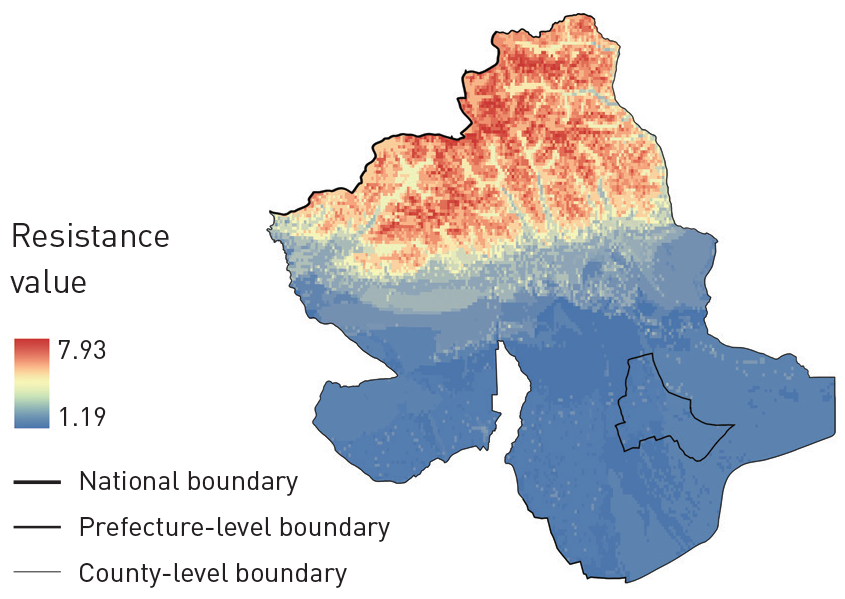
研究提出通過(guò)“有潛力”和“有需求”的原則識(shí)別碳匯潛力帶�,用以連接碳匯腹地與重要區(qū)。其中����,“有潛力”指能以較低的成本進(jìn)行生態(tài)修復(fù)、提高碳匯����;“有需求”指易產(chǎn)生碳排放、需考慮就地消納��。根據(jù)上述原則選取相應(yīng)的阻力因子(坡度����、高程�����、土地利用���、年積溫、年平均降水量和人口密度)��,采用最小累積阻力模型計(jì)算�����,以碳匯腹地與碳匯重要區(qū)作為源地�,將低阻力區(qū)域識(shí)別為碳匯潛力帶。
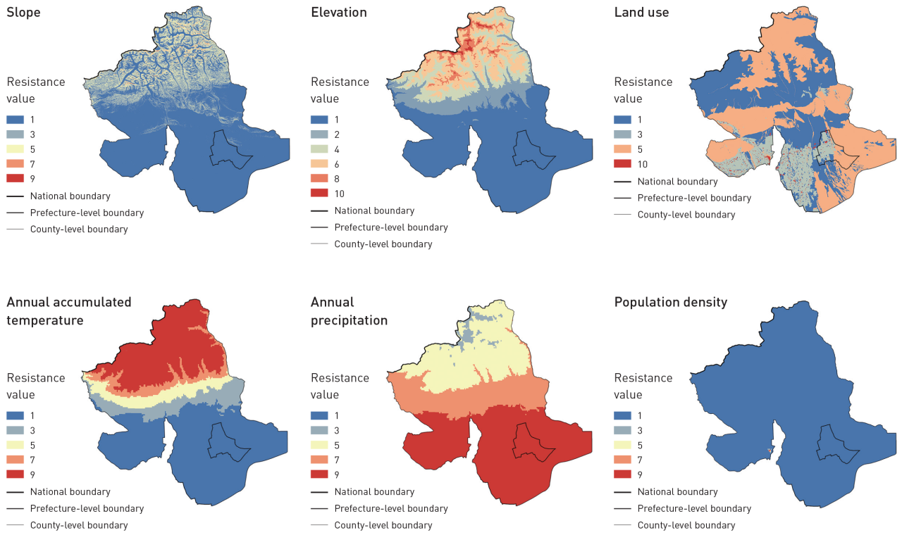
研究區(qū)域阻力因子賦值 ? 張?chǎng)ノ?,楊穎,袁藝�����,韓靜怡���,李迪華
研究區(qū)域綜合阻力面 ? 張?chǎng)ノ?��,楊穎,袁藝�����,韓靜怡����,李迪華
碳匯腹地、重要區(qū)與潛力帶的土地利用現(xiàn)狀進(jìn)行分析����,提煉土地利用的典型空間模型。參考已有研究���,針對(duì)不同土地利用空間模型擬定生態(tài)修復(fù)策略與管理措施����,以期實(shí)現(xiàn)維持林地碳匯�、適當(dāng)提升未利用土地碳匯、顯著提升耕地與草地碳匯的目標(biāo)�。
結(jié)果顯示,溫宿縣不同區(qū)域間NEP值相差較大���,碳吸收能力的高低整體呈錯(cuò)落分布��。NEP低值區(qū)域主要位于溫宿縣南部戈壁和裸巖石質(zhì)地區(qū)域����,其碳吸收能力最弱;同時(shí)���,常年積雪覆蓋��、植被稀少的北部天山高海拔區(qū)域碳吸收能力也較弱����。NEP高值區(qū)域主要位于天山南麓海拔2000~3000m的帶狀區(qū)域�,該區(qū)域自然林地與草地生長(zhǎng)狀態(tài)良好,碳吸收能力最強(qiáng)�;同時(shí),南部以農(nóng)田為主的人工植被區(qū)域也具有較強(qiáng)的碳吸收能力�。
NEP空間分布 ? 張?chǎng)ノ模瑮罘f����,袁藝,韓靜怡�����,李迪華
在土壤碳儲(chǔ)量方面,溫宿縣中部土壤總碳儲(chǔ)量最高���,南部次之,北部最低�。其中,縣域中部和南部部分區(qū)域�����、東南部沖積平原的表土與底土無(wú)機(jī)碳含量均較高��;天山南麓海拔2000~3000m區(qū)域的表土有機(jī)碳含量相對(duì)較高���;而底土有機(jī)碳則整體較低����,僅在縣域中部海拔1500~2000m的區(qū)域及南部平原的少量區(qū)域有著較高的底土有機(jī)碳含量���。
土壤總碳儲(chǔ)量空間分布圖 ? 張?chǎng)ノ?,楊穎�,袁藝��,韓靜怡�,李迪華
表土無(wú)機(jī)碳空間分布圖 ? 張?chǎng)ノ?,楊穎,袁藝���,韓靜怡�����,李迪華
底土無(wú)機(jī)碳空間分布圖 ? 張?chǎng)ノ?���,楊穎�����,袁藝���,韓靜怡�,李迪華
表土有機(jī)碳空間分布圖 ? 張?chǎng)ノ?����,楊穎,袁藝�,韓靜怡,李迪華
底土有機(jī)碳空間分布圖 ? 張?chǎng)ノ?,楊穎,袁藝�,韓靜怡,李迪華
溫宿縣植被碳儲(chǔ)量總值為361.013×10⁴t�。其中,溫帶禾草��、雜類草鹽生草甸碳儲(chǔ)量最高���,共計(jì)89.059×10⁴t;以兩年三熟或一年兩熟旱作和落葉果樹(shù)園為代表的栽培植被次之�����,碳儲(chǔ)量為65.322×10⁴t���;寒溫帶和溫帶山地針葉林雖然面積較小�,但其碳密度值最大��,碳儲(chǔ)量也相對(duì)較高����,為57.007×10⁴t����;溫帶草原化灌木荒漠由于面積極少且碳密度值較低��,其碳儲(chǔ)量最少���,僅為0.8×10⁴t��。
綜合植被碳儲(chǔ)量和土壤碳儲(chǔ)量情況可知���,溫宿縣現(xiàn)有碳儲(chǔ)量最豐富的區(qū)域主要為縣域南部平原與天山南麓,其現(xiàn)狀土地利用以林地���、草地��、耕地為主��。在后續(xù)生態(tài)修復(fù)過(guò)程中�,應(yīng)重點(diǎn)關(guān)注其土地開(kāi)發(fā)和流轉(zhuǎn)情況�,保證其碳儲(chǔ)量不被大面積擾動(dòng)。
碳匯重要性評(píng)價(jià)結(jié)果顯示,溫宿縣不同地理環(huán)境的碳匯重要性差異較大�����。其中�����,天山南麓海拔2000~3000m的區(qū)域碳匯重要性最高����,評(píng)級(jí)結(jié)果以“極高”和“高”為主;南部和東南部平原的連片農(nóng)田區(qū)域具有較高的碳匯重要性����,評(píng)級(jí)結(jié)果以“高”和“中”為主�����;而在北部天山海拔3000m以上的區(qū)域�����、縣域中部和東南部的戈壁與裸巖石質(zhì)地區(qū)域���,碳匯重要性評(píng)級(jí)結(jié)果都以“極低”為主��,其中穿插有少量“低”值區(qū)�����。
碳匯重要性水平空間分布 ? 張?chǎng)ノ?��,楊穎���,袁藝,韓靜怡����,李迪華
研究識(shí)別得到溫宿縣碳匯腹地一處、碳匯重要區(qū)兩處�����,以及總面積達(dá)2259.81km2的碳匯潛力帶���。其中���,碳匯腹地位于溫宿縣北部海拔2000~4000m的天山南麓區(qū)域,面積為1083.87km2;兩處碳匯重要區(qū)分別位于溫宿縣南部與西南部的平原區(qū)域��,總面積為1899.69km2��;碳匯潛力帶主要位于縣域中部�。碳匯腹地的土地利用類型以高、中�、低覆蓋度草地為主,面積占比分別為48.60%�����、11.48%和31.76%����;碳匯重要區(qū)的土地利用類型以旱地為主,面積占比高達(dá)86.63%��;碳匯潛力帶土地利用類型以低覆蓋度草地與未利用裸巖石質(zhì)地為主�����,面積占比分別為51.28%和24.81%�����。
碳匯空間格局識(shí)別結(jié)果 ? 張?chǎng)ノ?���,楊穎,袁藝��,韓靜怡�����,李迪華
基于溫宿縣土地利用現(xiàn)狀組合類型���,團(tuán)隊(duì)提煉得到八種土地利用典型空間模型�。研究團(tuán)隊(duì)以碳增匯為導(dǎo)向提出了相應(yīng)的生態(tài)修復(fù)策略����,即高碳鞏固,戈壁保碳���、低碳利用��,保碳擴(kuò)展�、固碳補(bǔ)植���、固碳防治����、高碳維持、重點(diǎn)固碳監(jiān)測(cè)�;并因地制宜地?cái)M定生態(tài)修復(fù)和碳匯效應(yīng)提升措施。
生態(tài)修復(fù)策略 ? 張?chǎng)ノ?��,楊穎�,袁藝��,韓靜怡�����,李迪華
研究基于多源數(shù)據(jù)評(píng)估了溫宿縣碳匯現(xiàn)狀�,識(shí)別了縣域碳匯空間格局,并提出了以碳增匯為導(dǎo)向的國(guó)土空間生態(tài)修復(fù)規(guī)劃策略����。研究結(jié)果表明,草地與農(nóng)田或可成為中國(guó)西北干旱區(qū)固碳增匯重點(diǎn)關(guān)注的土地利用類型�。就本案例而言����,干旱少雨的氣候?qū)е铝值卦跍厮蘅h面積占比較小��、可以提供的碳匯效應(yīng)有限��,而草地與旱地則表現(xiàn)出較高的碳匯重要性���,是溫宿縣碳匯的主要來(lái)源。現(xiàn)有中國(guó)西北干旱區(qū)植被碳匯評(píng)估的相關(guān)研究也指出�,溫帶草原與高質(zhì)量農(nóng)田具有較大的碳匯量。在開(kāi)展中國(guó)西北干旱區(qū)生態(tài)修復(fù)時(shí)��,應(yīng)充分尊重本土植被的特點(diǎn)���,避免在植被類型轉(zhuǎn)換及維系非原生植被生長(zhǎng)過(guò)程中因物料����、能源等投入帶來(lái)的碳排放�����;并在保證大面積草地不被擾動(dòng)的基礎(chǔ)上�,改善草地管理措施,增加土壤的有機(jī)質(zhì)含量�����,從而提高碳儲(chǔ)量。在農(nóng)田的碳匯提升上���,可通過(guò)改變耕作制度��、控制農(nóng)資投入等減少土壤擾動(dòng)的農(nóng)作方式���,以及優(yōu)化人工管理措施的方法,進(jìn)一步提高農(nóng)田固碳增匯的能力�。
溫宿縣碳匯空間格局的識(shí)別結(jié)果也對(duì)中國(guó)西北干旱區(qū)的碳匯管理具有一定的借鑒意義。但溫宿縣的碳匯空間格局表明�����,除天山南麓的自然區(qū)域外�,南部人類活動(dòng)強(qiáng)度較高的農(nóng)村居民點(diǎn)及農(nóng)田區(qū)域仍然可以產(chǎn)生明顯的碳匯效應(yīng)。這再次凸顯了經(jīng)人為干預(yù)的景觀對(duì)干旱區(qū)固碳增匯的重要性���,未來(lái)研究可進(jìn)一步細(xì)化干旱區(qū)人工栽培植被的碳匯評(píng)估��,從而為人為管理固碳增匯措施的細(xì)化提供參考�。
本研究則從空間視角出發(fā)�,通過(guò)具體案例���,將碳匯現(xiàn)狀評(píng)估���、空間格局分析與規(guī)劃及具體修復(fù)策略擬定相結(jié)合�,提出了一種固碳增匯的空間途徑����。本研究的技術(shù)路線有助于將碳增匯目標(biāo)與其他生態(tài)修復(fù)目標(biāo)相結(jié)合,助力山水林田湖草沙的整體保護(hù)���、系統(tǒng)修復(fù)和綜合治理的實(shí)現(xiàn)�。
本研究運(yùn)用MCR識(shí)別碳匯潛力帶的方法具有試驗(yàn)性質(zhì)���,在后續(xù)研究成果轉(zhuǎn)向?qū)嵺`的過(guò)程中��,需要進(jìn)一步加強(qiáng)實(shí)地驗(yàn)證���。此外,后續(xù)研究可進(jìn)一步補(bǔ)充收集實(shí)測(cè)數(shù)據(jù)�����,完善數(shù)據(jù)的時(shí)間與精度,提高碳匯評(píng)估的全面性與準(zhǔn)確性�����;同時(shí)�����,整體統(tǒng)籌碳匯與其他生態(tài)問(wèn)題�,將促進(jìn)國(guó)土空間生態(tài)修復(fù)與綜合治理進(jìn)一步朝碳增匯的方向發(fā)展。
[1] China Meteorological News. (2021, August 10). Report Made by the Working Group I from IPCC AR6. China Meteorological Administration.
[2] Xinhua News Agency. (2020, September 22). President Xi Jinping’s Remarks at the General Debate of the 75th Session of the United Nations General Assembly. Chinese Government Website.
[3] Xinhua News Agency. (2021, March 15). President Xi Jinping’s Remarks at the ninth meeting of the Central Committee for Financial and Economic Affair. Chinese Government Website.
[4] Lao, B., Zhuo, W., & Zhu, R. (2020). The rebirth of tropical rainforest—Ecological restoration planning for Sanda Mountain of Xishuangbanna, China. Landscape Architecture Frontiers, 8(1), 108–125.
[5] Lu, F., Hu, H., Sun, W., Zhu, J., Liu, G., Zhou, W., Zhang, Q., Shi, P., Liu, X., Wu, X., Zhang, L., Wei, X., Dai, L., Zhang, K., Sun, Y., Xue, S., Zhang, W., Xiong, D., Deng, L., Liu, B., Zhou, L., Zhang, C., Zheng, X., Cao, J., Huang, Y., He, N., Zhou, G., Bai, Y., Xie, Z., Tang, Z., Wu, B., Fang, J., Liu, G., & Yu, G. (2018). Effects of national ecological restoration projects on carbon sequestration in China from 2001 to 2010. PNAS, 115(16), 4039–4044.
[6] Hou, R., Xia, C., Chen, J., Zheng, Q., Li, H., Huang, J., Huang, X., Deng, J., Han, X., An, T., Hao, Y., & Gou, L. (2022). Carbon storage and carbon sink of forest land and other biomass in the Yangtze River Economic Belt. Acta Ecologica Sinica, 42(23), 9483–9498.
[7] Xie, L., Bai, Z., Yang, B., Chen, M., Fu, S., & Mao, Y. (2023). Carbon sequestration assessment methods at home and abroad for terrestrial ecosystems: Research progress in achieving carbon neutrality. Earth Science Frontiers, 30(2), 447–462.
[8] Lin, Z., Wang, P., Liu, Q., & Yang, Y. (2022). Spatio-temporal evolution characteristics of cultivated land carbon storage and identification of carbon sink areas in Huaihai Economic Zone from 2005 to 2020. Transactions of the Chinese Society of Agricultural Engineering, 38(19), 259–268.
[9] Han, Y., Zhang, S., & Yin, L. (2019). Quantifying the carbon storage capacity and its spatial distribution patterns of green spaces in a metropolitan area: A case study of Seoul, South Korea. Landscape Architecture Frontiers, 7(2), 55–65.
[10] Zhang, H., Peng, Q., Wang, R., Qiang, W., & Zhang, J. (2020). Spatiotemporal patterns and factors influencing county carbon sinks in China. Acta Ecologica Sinica, 40(24), 8988–8998.
[11] Zhang, H., He, J., Yang, X., & Peng, Q. (2022). Zoning and governance of county ecological space for the increase of carbon sinks: A case study of the Beijing-Tianjin-Hebei region. Planners, 38(1), 32–40.
[12] Jiang, J., Xu, J., Wu, W., Zhou, L., & Sun, D. (2014). Patterns and dynamics of China’s human-nature carbon source-sink system. Journal of Natural Resources, 29(5), 757–768.
[13] Fan, Y., & Wei, F. (2022). Contributions of natural carbon sink capacity and carbon neutrality in the context of net-zero carbon cities: A case study of Hangzhou. Sustainability, 14(5), 2680.
[14] Kong, F., Ying, L., Wen, W., & Liang, M. (2021). Exploring carbon sequestration and sink enhancement based on ecological restoration of territorial space. Natural Resource Economics of China, 34(12), 70–76.
[15] Li, M., & Wu, C. (2022). Application of NbS in terrestrial ecological restoration project to promote carbon sequestration and sink in China. Natural Protected Areas, 2(4), 25–31.
[16] Piao, S., Yue, C., Ding, J., & Guo, Z.(2022). Perspectives on the role of terrestrial ecosystems in the ‘carbon neutrality’ strategy. Science China Earth Sciences, 65(6), 1178–1186.
[17] Zhao, J., Liu, Y., & Han, F. (2023). Thoughts on the path of increasing carbon sink in grassland under carbon peak and carbon neutrality targets. Acta Agrestia Sinica.
[18] Zhou, Q., Wang, Q., Zheng, Z., & Liu, W. (2023). Carbon neutrality and ecological remediation in agricultural grain production. Journal of Agro-Environment Science, 42(1), 1–10.
[19] Li, W., Li, J., Zhang, Y., Li, P., & Han, J. (2022). Ecological restoration technologies for lake wetlands for carbon peaking and neutrality. Journal of Nanjing Forestry University (Natural Sciences Edition), 46(6), 157–166.
[20] Yang, L. (2016). Evaluations of carbon sink benefit under the ecological restoration model of Karst rocky desertification [Master’s thesis]. Guizhou Normal University.
[21] Kang, B., Li, M., & Li, H. (2021). A case study of Nature-based Solutions in coastal zone blue carbon ecosystems restoration. Landscape Design, (4), 10–15.
[22] Zhang, X., Wei, W., Zhou, L., Guo, Z., Li, Z., Zhang, J., & Jie, B. (2021). Analysis on spatio-temporal evolution of ecological vulnerability in arid areas of northwest China. Acta Ecologica Sinica, 41(12), 4707–4719.
[23] Lu, Y., Zhao, Y., & Dong, J. (2022). Ecological security evaluation and driving force analysis of three-dimensional ecological footprint in northwestern China. Acta Ecologica Sinica, 42(4), 1354–1367.
[24] Pan, J., & Wen, Y. (2015). Estimation and spatial-temporal characteristics of carbon sink in the arid region of northwest China. Acta Ecologica Sinica, 35(23), 7718–7728.
[25] Pei, Z., Zhou, C., Ouyang, H., & Yang, W. (2010). A carbon budget of alpine steppe area in the Tibetan Plateau. Geographical Research, 29(1), 102–110.
[26] Wang, Y., Luo, G., Wang, Y., Han, Q., Fan, B., & Chen, Y. (2014). Vegetation and soil carbon density in arid region of Central Asia. Arid Land Geography, 37(2), 239–249.
[27] Lai, L. (2010). Carbon emission effect of land use in China [Master’s thesis]. Nanjing University.
[28] Yang, M., Yang, X., Zhao, Y., Huang, Q., Li, C., Cao, W., Chen, A., Gu, Q., Li, Z., & Wang, S. (2023). Estimated carbon storage and influencing factors of alpine grassland in the source region of the Yellow River. Acta Ecologica Sinica, 43(9), 3546–3557.
[29] Wang, S., Zhou, C., & Luo, C. (1999). Studying carbon storage spatial distribution of terrestrial natural vegetation in China. Progress in Geography, 18(3), 238–244.
[30] Sun, X., & Liu, H. (2010). Effects of land use change on wetland landscape connectivity and optimization assessment of connectivity—A case study of wetlands in the coastal zone of Yancheng, Jiangsu. Journal of Natural Resources, 25(6), 892–903.
[31] Fu, F., Liu, Z., & Liu, H. (2021). Identifying key areas of ecosystem restoration for territorial space based on ecological security pattern: A case study in Hezhou City. Acta Ecologica Sinica, 41(9), 3406–3414.
[32] He, B., Ding, J., Li, H., Liu, B., & Chen, W. (2018). Spatiotemporal variation of vegetation phenology in Xinjiang from 2001 to 2016. Acta Ecologica Sinica, 38(6), 2139–2155.
[33] Xiong, Q., He, Y., Li, T., & Yu, L. (2019). Spatiotemporal patterns of vegetation coverage and response to climatic and topographic factors in growth season in southwest China. Research of Soil and Water Conservation, 26(6), 259–266.
[34] He, Y., Kong, Z., Hu, X., Zhang, J., Wang, M., Peng, C., & Zhu, Q. (2022). Water and heat conditions separately controlled inter-annual variation and growth trend of NDVI in the temperate grasslands in China. Acta Ecologica Sinica, 42(2), 766–777.
[35] Jiao, S., Liu, Y., Han, Z., Zhou, K., Hu, L., & Liu, T. (2021). Determining priority areas for land ecological restoration based on ecological network-human disturbance: A case study of Changsha-Zhuzhou-Xiangtan Urban Agglomeration. Journal of Natural Resources, 36(9), 2294–2307.
[36] Shao, R., Wang, W., Shi, K., & Liu, Y. (2014). Research for restoration of soil and vegetation in human disturbance zone of road in high-cold grassland area. Research of Soil and Water Conservation, 21(6), 181–186, 192.
[37] Wang, J., & Zhang, J. (2001). Comparing several methods of assuring weight vector in synthetical evaluation. Journal of Hebei University of Technology, 30(2), 52–57.
[38] Tao, X., Zhang, R., Xu, H., & Zhu, J. (2006). Assessment of City’s sustainable development based on improved entropy method. Journal of Arid Land Resources and Environment, 20(5), 38–41.
[39] Yu, K. (1999). Landscape ecological security patterns in biological conservation. Acta Ecologica Sinica, 19(1), 8–15.
[40] Yu, G., Zhu, J., Xu, L., & He, N. (2022). Technological approaches to enhance ecosystem carbon sink in China: Nature-based Solutions. Bulletin of the Chinese Academy of Sciences, 37(4), 490–501.
[41] Qin, G., & Tian, M. (2022). The development opportunities and implementation path of forestry carbon sequestration under the target of carbon peak and carbon neutrality. Administrative Reform, (1), 45–54.
[42] Wang, C., Wang, R., & Lin, Z. (2010). Carbon sequestration estimation by different tree species and reforestation types in forest ecosystem. Ecology and Environmental Sciences, 19(10), 2501–2505.
[43] Zhang, Y., Yang, G., Liu, N., Chang, S., & Wang, X. (2013). Review of grassland management practices for carbon sequestration. Acta Prataculturae Sinica, 22(2), 290–299.
[44] Xue, C., Li, Y., Hu, C., & Yao, S. (2022). Study on spatio-temporal pattern of conservation tillage on net carbon sink in China. Journal of Natural Resources, 37(5), 1164–1182.
[45] Zheng, J., Cheng, K., Pan, G., Smith, P., Li, L., Zhang, X., Zheng, J., Han, X., & Du, Y. (2011). Perspectives on studies on soil carbon stocks and the carbon sequestration potential of China. Chinese Science Bulletin, 56(26), 2162–2173.
[46] Huo, H., Zhang, J., Ma, A., & Huo, J. (2018). Progress and prospects of soil carbon cycle in arid deserts. Journal of Northwest Forestry University, 33(1), 98–104.
[47] Li, Z., Shan, N., Wang, Q., Li, W., Wang, Z., Bao, S., Dou, H., Ao, W., Pang, B., & Wang, W. (2022). Estimation of vegetation carbon source/sink and analysis of its influencing factors in Hulun Lake Basin from 2013 to 2020. Journal of Ecology and Rural Environment, 38(11), 1437–1446.
[48] Qu, F., Lu, N., & Feng, S. (2022). Effects of land use change on carbon emissions. China Population, Resources and Environment, 21(10), 76–83.
[49] Li, Y., Hao, X., Zhang, J., Fan, X., & Zhao, Z. (2022). Spatial and temporal variation of net carbon sink function of farmland in Aksu oasis in the past 17 years. Arid Zone Research, 39(4), 1303–1311.
[50] Li, M., Liu, S., Sun, Y., & Liu, Y. (2021). Agriculture and animal husbandry increased carbon footprint on the Qinghai-Tibet Plateau during past three decades. Journal of Cleaner Production, (278), 123963.
[51] Wu, Y., Zhang, M., Yang, M., & Jun, Y. (2022). Exploration of the implementation of carbon neutralization in the field of natural resources under the background of sustainable development—An overview. International Journal of Environmental Research and Public Health, 19(21), 14109.
[52] Xu, Q., Dong, Y., & Yang, R. (2018). Influence of the geographic proximity of city features on the spatial variation of urban carbon sinks: A case study on the Pearl River Delta. Environmental Pollution, 243(A), 354–363.
[53] Cao, Y., Wang, J., & Li, G. (2019). Ecological restoration for territorial space: Basic concepts and foundations. China Land Science, 33(7), 1–10.
[54] Han, Y., Zhang, Q., Zhang, S., & Yin, L. (2021). Optimizing the habitat quality of the East Lake Scenic Area in Wuhan. Chinese Landscape Architecture, 37(9), 95–100.
[55] Xu, S., Wang, H., & Kong, W. (2021). Study on mountainous optimization of ecological security pattern based on MCR model from the perspective of disaster prevention: A case study of Beijing-Tianjin-Hebei mountainous area. Journal of Catastrophology, 36(2), 118–123.
本文引用格式 / PLEASE CITE THIS ARTICLE AS
Zhang, Q., Yang, Y., Yuan, Y., Han, J., & Li, D. (2024). Research on the territorial ecological restoration of counties for the increase of carbon sinks—A case study of Wensu County, Xinjiang Uygur Autonomous Region, China. Landscape Architecture Frontiers, 12(3), 10?26. https://doi.org/10.15302/J-LAF-0-020017
編輯 | 高雨婷����,周佳怡
翻譯 | 肖杰,高雨婷����,周佳怡
制作 | 高雨婷
媒體發(fā)布 | 馬哲

版權(quán)聲明:本文版權(quán)歸原作者所有,請(qǐng)勿以景觀中國(guó)編輯版本轉(zhuǎn)載�����。如有侵犯您的權(quán)益請(qǐng)及時(shí)聯(lián)系��,我們將第一時(shí)間刪除。
投稿郵箱:info@landscape.cn
項(xiàng)目咨詢:18510568018(微信同號(hào))

 京公海網(wǎng)安備 110108000058號(hào)


